





































How new roads, bridges and public spaces are reshaping the Pasig-Cainta corridor
Sometimes, seeing the potential of a neighborhood means looking beyond what is already there.
When Empire East launched The Cambridge Village in 2001, the stretch of East Bank Road along the Pasig-Cainta boundary looked considerably different from the increasingly connected corridor it is today.
The road was narrower. Development was more dispersed. Crossing the Manggahan Waterway meant relying on a limited number of bridges. And many of the destinations that would eventually transform the wider C-5 corridor were either much smaller or had yet to emerge.
But the location had something important going for it: it sat between places that were growing.
Pasig on one side. Cainta and the rest of Rizal on the other. Ortigas to the west. And a road network that, over the succeeding decades, would increasingly connect the area to more parts of Metro Manila.
More than two decades later, that once-peripheral location is beginning to look a lot more like a crossroads.
2001: Seeing what the neighborhood could become
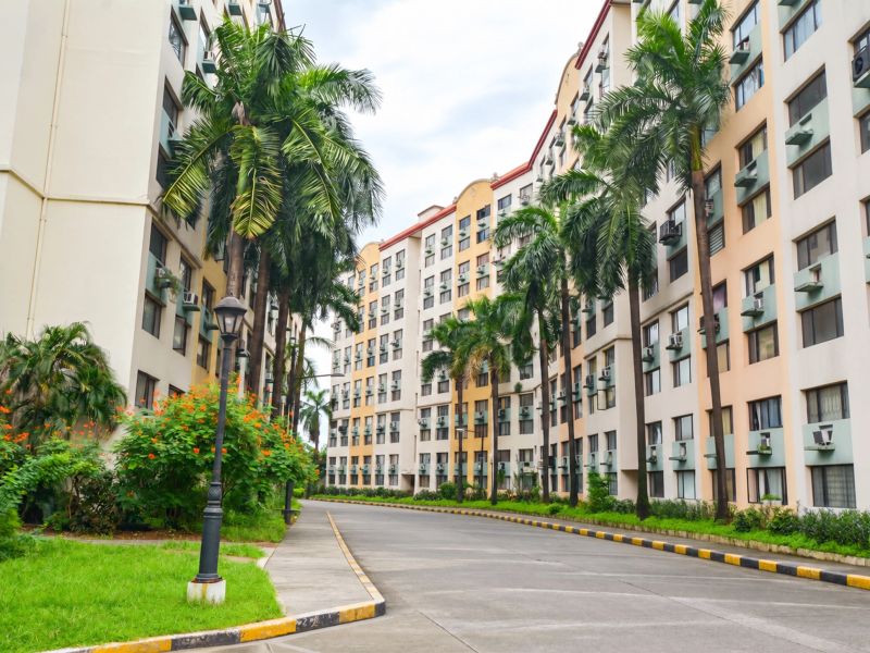
The Cambridge Village was envisioned as an eight-hectare “micro city” along East Bank Road in the Pasig-Cainta area.
Launched at a time when large-scale residential development in this part of the metro was still relatively limited, the community would eventually grow to 37 mid-rise residential towers, together with commercial establishments, recreational spaces and other facilities within the development.
Today, all 37 residential buildings have been completed. But while the community was growing within its gates, the neighborhood outside was changing too.
East Bank Road itself became wider and busier, increasingly serving motorists traveling between Pasig and communities farther east.
What was once primarily a road following the Manggahan Waterway was becoming part of a much larger urban network.
The road gets wider. The connections get closer.
One of the biggest changes has been something residents experience every day: East Bank Road itself.
Over the years, sections of the corridor were widened and improved as traffic and development increased around Pasig, Cainta and neighboring areas.
At its northern end, East Bank Road connects with the road network around Amang Rodriguez Avenue and Ortigas Avenue Extension. From there, routes such as Calle Industria provide access toward C-5 and the Eastwood City area.
That connection has become more significant as the C-5 corridor evolved into a major employment and commercial axis of Metro Manila.
In the other direction, East Bank Road continues toward communities in Cainta and Taytay, with connections to the wider Rizal road network.
The result is a road that no longer simply serves the neighborhoods immediately beside it. It has become part of the everyday movement between Rizal and Metro Manila.
Across the waterway
Roads, however, tell only half the story. Bridges gradually made the communities on opposite sides of the Manggahan Waterway easier to reach.
One familiar crossing is Javier Bridge along F. Legaspi Street, formerly known as Legaspi Bridge, which connects the East Bank side with Maybunga and the road network deeper into Pasig. Over the years, the bridge has undergone improvements and rehabilitation as the volume of people and vehicles moving through the area increased.
For residents along East Bank Road, that meant something simple but important: more ways to get to the other side. And soon, there will be another.
A new way toward C-5
Now under construction is Eastbank-Westbank Bridge 2, just a few meters away from the main gate of The Cambridge Village. Scheduled for completion in mid-2027, this new four-lane bridge is being developed as part of the government's wider infrastructure program for Metro Manila.
Its location is particularly significant. The new bridge is being built between the existing Javier and Barkadahan bridges, creating another crossing for communities along East Bank Road.
More importantly, the new route will cross the Manggahan Waterway and connect the East Bank side to Mercedes Avenue. From there, the road network continues through C. Raymundo Avenue and Pasig Boulevard Extension toward C-5.
For residents of The Cambridge Village, that means another alternative for reaching the western side of Pasig and the larger C-5 network—where business districts, offices, commercial centers and other urban destinations have steadily expanded over the past two decades.
Not just roads anymore
Perhaps one of the more unexpected signs of East Bank Road's transformation isn't another road or bridge at all. It's a skate park.
In February 2025, Pasig City opened the East Bank Linear Park and Skate Park in Barangay Sta. Lucia—the city's first dedicated skate park, just a few minutes away from The Cambridge Village. Built as a public recreational space, the development includes landscaped areas, gazebos, seating and skating facilities.
Its presence says something interesting about how the neighborhood is changing. Infrastructure along the waterway is no longer being thought of purely in terms of moving vehicles from one point to another. There is also room for people to walk, gather, play and stay.
In June 2025, Pasig even celebrated Go Skateboarding Day with a “push parade” beginning at Maybunga Rainforest Park and ending at the new East Bank Skate Park.
A corridor once defined largely by roads and movement was becoming a place for recreation too.
2001 to today: a neighborhood grows around you
A lot can happen to a neighborhood in 25 years. Roads become wider. Old bridges become busier. New connections appear. Public spaces open. Employment centers grow within reach. And another bridge begins to rise.
Meanwhile, the community that Empire East began developing here in 2001 has matured as well. Today, The Cambridge Village is complete, with everyday conveniences that continue to grow around its residents.
None of these changes happened overnight. They came one road improvement, one bridge, one development and one public space at a time.
Perhaps that is what makes the story of this part of Pasig-Cainta interesting. Twenty-five years ago, Empire East looked at a location along East Bank Road and saw what it could become. Today, the roads and bridges around it are still evolving, opening new ways to move, connect and experience the neighborhood.
And in many ways, that is what #MovingLivesForward looks like—not simply moving from one place to another, but seeing a community grow, connections improve, and everyday life move forward with them.
Because sometimes, the neighborhood doesn't necessarily move closer to the city.
The city keeps finding new ways to connect to the neighborhood.
 Empire East Highland City
 The Paddington Place
 Mango Tree Residences
 Kasara Urban Resort Residences
 Covent Garden
 The Rochester
 Pioneer Woodlands
 Little Baguio Terraces
 San Lorenzo Place